M. Shahidul Islam
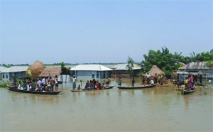
The power of the people lay in the inalienable right to choosing nominees to govern them. If a government does not need votes to assume or stay in power, it can willy-nilly abandon the people to their fates. This is what had happened since August 13 when heavy down pouring within and an onrush of waters from across the borders in India began to create one of the worst flooding of this decade in Bangladesh.
Since the onset of this deluge, the media was vociferous as village after village in the char areas of northern Bangladesh started being devoured by swelling flood waters. The government, instead of rushing to help the marooned, remained oblivious and focused more on alleging the opposition BNP of terrorism, arson, espionage, coups and murders. Obsessed with re-writing the history, the ruling oligarchs of the AL and its arm-chair- leftist appendages had miserably failed to extend any helping hands so far to the millions of flood victims struggling to survive.
Call an election
This failure is unpardonable. For, by August 15, over 100,000 people became homeless and the number of disaffected people kept rising. By August 25, number of displaced and the dispossessed rose to nearly one million. The flooding also spread from north and northeast Nilphamari, Lalmonirhat, Kurigram, Rangpur, Gaibandha, Jamalpur, Sirajganj, Sunamganj and Sylhet to Dhaka’s outskirts; including to the districts of Tangail, Munshiganj, etc.
Since August 25, so called flood protection embankments breached in three different points, washing away umpteen more villages and their inhabitants. A major ferry ghat in Dhaka’s outskirt collapsed on Tuesday, snapping movement from Dhaka to the south-western Bangladesh.
The crisis warranted declaration of national emergency. In any civilized nation, even if a city or a village faces obliteration for any reason, the nation as a whole rushes to its rescue. The failure of the ruling AL even to take into cognizance the gravity of the crisis is an offense for which it should resign and call for an election.
This failure is colossal and it’s no more in the perceptive level. Even a belated warning from a crony-controlled Bangladesh Water Development Board (WDB) did not break the silence of the government. The WDB said on August 30: Water at 20 points of 15 major rivers was flowing above the danger level and that “the water in the Brahmaputra, Jamuna, Padma and the rivers around the capital Dhaka Buriganga, Balu and Turag – and the Tongi canal might rise in the next 72 hours.”
By then, flooding had already engulfed and affected more than half of the country, spreading to Shariatpur, Madaripur, Munshiganj, Rajbari and Faridpur. Following nine confirmed deaths and the numbers of the victims rising to over 1.5 million, virtually nothing was done by a dysfunctional regime either to rescue the marooned, or to provide them any semblance of succor.
Sources of flooding
This is not an earth-quake like unpredictable calamity. Incessant down pouring aside, water rushes in every monsoon from the 57 rivers that enter Bangladesh from the Indian states of Arunachal Pradesh, Bihar, Monipur, Assam, Mizoram, Tripura, Meghalaya and West Bengal. And, of the about 4,000 dams India had constructed since 1947 to regulate its water flows, over half of them impacts flows toward Bangladesh by depriving the Bangladesh landmass of much needed waters in the dry season and by discharging excessive waters in the monsoon to exacerbate the flooding.
Geologists say there are over 700 rivers and their tributaries snaking the Bangladesh landmass. Yet, the most vulnerable for flooding are the Jamuna-Brahmaputra basin stretching over 292 kilometers from northern Bangladesh to its confluence with the Padma. Mighty Brahmaputra originates from the Yarlung Zangbo Jiang in China’s Xizang Region (Tibet) and flows through India’s Arunachal Pradesh, whence it becomes known as the Brahmaputra (“Son of Brahma”). Inside India, it receives waters from five major tributaries before entering Bangladesh after traversing some 740 kilometers. Upon merging with the Teesta in Bangladesh, Brahmaputra renames itself as Jamuna.
Cursing Padma
Massive flooding also affects the people living along the Padma-Ganges basin and its two vital arteries: a 258-kilometer segment, the Ganges, flowing from India to its confluence with the Jamuna some 72 kilometers west of Dhaka, and, the 126-kilometer long Padma that runs from the Ganges-Jamuna confluence to the Meghna at Chandpur. The Padma-Ganges basin encompasses hundreds of small rivers and tributaries to form the core delta that is known as Bangladesh. The vast water system is over 2,100 km long. Its curses have been tragic for decades, especially since the Indian commissioning of the Farakka barrage in the 1970s.
Until recently, flooding has been relatively less severe along the third river system, the Surma-Meghna basin, which stretches from north-eastern Sylhet to Chandpur whence it meets with the Padma. This is the longest river system, about 669 km long, and it joins the fourth river system known as the Padma-Meghna basin that traverses another 145 km before merging with the Bay of Bengal.
Simply put, over 1.5 million sq. km area comes under these four river systems and millions of Bangladeshis reside in the thousands of chars (islets) sitting in the midst of these mighty rivers. Cumulatively, they discharge the world’s second highest flow of charging water in the monsoon.
Although there is another river system in Bangladesh, the Karnaphuli and its attributes, its catchment areas lay mostly in the hilly region of Chittagong and it has never been vulnerable to serious flooding. Excepting occasional flooding in the Feni river basin, the 420 km long Karnaphuli system comprising of the Feni, Karnaphuli, Sangu, and Matamuhari rivers has always been a blessing for Bangladesh.
Water as weapon
Look differently to get assured that flooding does not occur due to excessive rain only, as the pro-Indian apologists insist. The very fact that the river systems in Bangladesh generate about 140,000 cubic meters of water per second during the Monsoon and only about 7,000 cubic meters per second in dry season is indicative of the causes of massive flooding lying in water management in the upstream.
The intrinsic geographic features of the country also attest to the fact that the water retention capacity is supposed to be higher in dry season unless the flows are blocked from the upstream. The northern part of the country sits on an altitude up to 105 meters above sea level while rest of the country is barely 10 meters above the sea level. Based on such calculations, about 20,000 square kilometers of the total landmass of Bangladesh is supposed to remain covered with water round the year, which is never the case in the dry season.
Multiple threats
The world’s 261 international river basins, covering 45 percent of the mother earth’s land surface (excluding Antarctica), are shared by more than one nation. Yet, Bangladesh being a lower riparian and militarily weaker country, India always used the international water as a potent weapon to subdue Bangladesh. The flooding aside, Bangladesh faces perhaps the gravest ecological threat in the world, thanks to India.
For decades, the Farakka barrage has resulted in Bangladesh’s salinity front stretching up to 280 km upstream from the sea-coast; the salinity level in the surface water increased 500 micro-mhos to 29,000 micro mhos at Khulna, exceeding the safe limit by several times; ground water salinity increased from 200 m mhos to about 3,000 m mhos at different places; one of the largest mangrove forests, the Sunderban, had already shown its dying face due to increased Salinity level in the estuarine rivers flowing through it; industrial growth had retarded considerably due to non-availability of potable water during the dry months (4 – 6 month); and, the agriculture has been suffering due to shortage of irrigation water during half of the year (dry season).
It took a long time since Dhaka’s move against India at the UN in 1976 to have a workable, but lopsided, agreement signed with India on sharing of the Ganges water. Besides, India has been told and retold by the civic society, the media, the NGOs and the UN not to disrupt the regional environmental balance by arbitrarily managing the waters that flow from the Himalayas through Indian territories to the Bay of Bengal via Bangladesh. The cruel neighbor, however, remains as yet defiant and uses water as a weapon of mass destruction.
Diplomacy & water convention
Studies show, about 30 major rivers in the flood-hit northern Bangladesh gets very little water in the dry season due to India’s systematic controlling of waters through dams and canals that hold and divert waters to Indian hinterland. During the monsoon, the floodgates are slammed open, causing massive flooding in Bangladesh and sparing much of the Indian river- basins from such devastations. This behavior cannot be accepted any more.
The customary law of equitable utilization of commonly used water refers to both the sharing and the management of the water resources. India has no right to arbitrarily release waters in the upstream in the monsoon and retain waters in the dry season.
The UN General Assembly has codified the rule of equitable utilization in Article 5 of its Convention on the Non-Navigational Uses of International Watercourses, and, the Assembly approved the Convention on May 21, 1997 by a vote of 104–3. The UN Convention also embraced a second principle, known as the “no-harm rule,” which, in Article 7, states that “watercourse nations, in utilizing an international watercourse, shall take all appropriate measures to prevent the causing of significant harm to other watercourse nations.”
The Convention reflected the true intent of the Customary International Law and, its reading was confirmed by the International Court of Justice in its 1997 ruling on the Danube River Case (Hungary v. Slovakia).
That notwithstanding, since blaming India alone does not save the lives of our own folks, we must wage a diplomatic war in the international forays against such Indian aggressions on one hand, and, instead of spending lofty sums on flyovers in Dhaka and other major metropolises, start cementing our river banks to save this nation from a looming devastation that is proving more hazardous by the day.
Source: Weekly Holiday


