New study suggests massive fault could cause big earthquake in city

“We don’t know if it’s tomorrow or if it’s not going to be for another 500 years,” Live Science quotes him as saying.
Syed Humayun Akhter, a professor of department of geology at Dhaka University and one of the researchers of the team, said, “The Indian plate is actually thrusting the Burma plate at a rate of 13 to 17 millimetres a year. A huge quantity of energy has accumulated there which has not been released in hundreds of years.”
Geologists have long been warning that Bangladesh is at the risk of a huge earthquake. They have been saying this by analysing historical earthquake records, recent seismic activity and geologic and tectonic set up of the country.
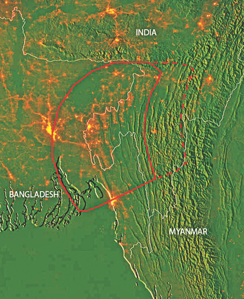
Prof Humayun said this is for the first time the joint research team came up with its long research findings based on velocity model using GPS data that the subduction zone of an area of 62,500 sq km between Chittagong and Sylhet is very active. The overriding Burma plate has been loading up with stress for at least 400 years without any release.
“This is for the first time we analysed scientific data and found actually how much energy is accumulated there,” he said.
“Overpopulated Bangladesh sits at the juncture of three tectonic plates — Indian plate to the west and southwest, Tibet sub-plate to the north, and the Burma plate to the east. Moreover, the plate boundary between India and Burma passes through Bangladesh — the eastern half belongs to Burma plate while the western half belongs to Indian plate,” he told The Daily Star.
Prof Humayun said Dhaka city would be the worst affected zone if adequate preparations are not taken immediately.
“The government is taking preparations. But we all know the pace of the preparation. Even if the earthquake hits after 20 years, it wouldn’t be enough time for Dhaka to take proper preparation,” he said.
It is quite difficult to take such a huge preparation overnight. Apart from the government initiatives, the people should be made aware of it, he suggested.
“So the only key to survival and minimise the damage is to make people aware,” Prof Humayun added.
HIDDEN FAULT LINES
Live Science reports that in the low-lying, waterlogged country of Bangladesh, the mighty Ganges and Brahmaputra rivers meet and form the world’s largest delta, eventually draining into the Bay of Bengal. The flow of these two massive rivers deposits a gigaton of sediment every year, the researchers said. This constant overlay of sediment obscured the geology below the Ganges Delta. But in recent years, scientists have learned that tectonic plates are colliding beneath the eons worth of sediment.
To get a better picture of how the plates buried deep below the surface were moving, Steckler and his colleagues worked with researchers at Dhaka University to install ultrasensitive GPS devices throughout Bangladesh between 2003 and 2014. They combined this data with plate-motion data collected from India and Myanmar, creating a map of the entire fault region.
The GPS network revealed that one plate is diving under the other deep beneath the surface in an area encompassing Bangladesh and parts of Myanmar and eastern India.
At the upper layers of the fault, the two plates are stuck together, building up strain that could produce a megathrust earthquake if it ruptures, the researchers said. Based on the strain data, the team estimates that the fault could unleash a maximum of a magnitude 8.2 to 9.0 earthquake, they reported in Nature Geoscience.
HUGE HAZARD ZONE
While an earthquake with a magnitude of 8 or greater has the potential to cause damage anywhere in the world, this particular region may be especially vulnerable. The researchers estimate that about 140 million people live within 60 miles (100 km) of the fault, including the 17 million people who live in the crammed megalopolis of the greater Dhaka area in Bangladesh.
The country also already faces problems with poor construction, Steckler said.
“I’ve seen them pumping sand to build up the ground level to build a 20-storey building,” Steckler told Live Science. “If there’s an earthquake [that ground is] going to liquefy and the building is just going to fall over.”
Not only would the region be incredibly vulnerable to widespread building collapse, but overcrowding could make it difficult to rescue people who survive the initial quake, Steckler said.
“Right now, the streets are clogged with traffic such that it’s impossible to drive around Dhaka on a normal day,” Steckler said. “If you fill the streets with debris, it’s really going to be impossible to get supplies and rescue equipment and things like that around.”
Source: The Daily Star


’র তথ্যচিত্র")


