Cyclone Fani Live Updates: Extremely Severe Storm Barrels towards East Coast
India launches mass evacuation, warns tourists, as cyclone bears down on east coast
Jatindra Dash 1 May 2019
BHUBANESHWAR, India (Reuters) – India has started evacuating hundreds of thousands of villagers living along its northeastern coastline ahead of a severe cyclone due to make landfall on Friday.
The state of Odisha has also moved in thousands of disaster management personnel to help those living in mud-and-thatch homes in low-lying areas take shelter from Severe Cyclonic Storm Fani.
“We are making best efforts to inform them about the cyclone and move these vulnerable people to cyclone shelters,” Bishnupada Sethi, the state’s special relief commissioner, told Reuters.
India launches mass evacuation, warns tourists, as cyclone bears down on east coast – Reuters
Two decades ago, a super-cyclone battered the coast of Odisha for 30 hours, killing 10,000 people. In 2013, a mass evacuation of nearly a million people saved thousands of lives.
Tropical Storm Risk cyclone tracker labeled Fani a category 3 storm on a scale of a low 1 to a powerful 5.
Additional reporting by Neha Dasgupta in NEW DELHI; Writing by Mayank Bhardwaj; Editing by Nick MacfieOur Standards:The Thomson Reuters Trust Principles.
Cyclone Fani Live Updates: Extremely Severe Storm Barrels towards East Coast
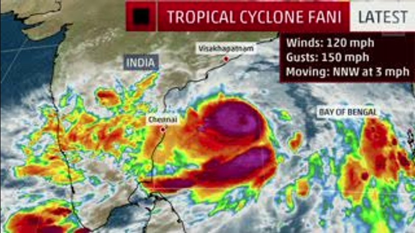
Cyclone Fani Nearing Landfall; Widespread Impacts Possible Along the Coast
Meteorologist Domenica Davis looks at the forecast for Tropical Cyclone Fani.
“We are making best efforts to inform them about the cyclone and move these vulnerable people to cyclone shelters,” Bishnupada Sethi, the state’s special relief commissioner, told Reuters.
India launches mass evacuation, warns tourists, as cyclone bears down on east coast – Reuters
Two decades ago, a super-cyclone battered the coast of Odisha for 30 hours, killing 10,000 people. In 2013, a mass evacuation of nearly a million people saved thousands of lives.
Tropical Storm Risk cyclone tracker labeled Fani a category 3 storm on a scale of a low 1 to a powerful 5.
Additional reporting by Neha Dasgupta in NEW DELHI; Writing by Mayank Bhardwaj; Editing by Nick MacfieOur Standards:The Thomson Reuters Trust Principles.
From weather.com
At a Glance
Cyclone Fani is currently an Extremely Severe Cyclonic Storm with 180-190 km/h winds, 600km off the Odisha coast.
At the moment it is expected to make landfall on Friday afternoon near Puri, Odisha.
There are huge storm surge and flooding risks for coastal Odisha and west Bengal, and also for Bangladesh.
There is a possibility of heavy rainfall on Thursday in coastal Andhra and south Odisha districts.
Fani is currently an ‘Extremely Severe’ storm. This map shows its expected trajectory as on Wednesday evening.(Image: The Weather Channel)4.00 pm IST
While the broad consensus is that it is set to make landfall in Puri some time Friday afternoon, different weather models have different estimates of the track and speed.
This map shows different track and speed forecasts for Fani, based on different models, by Friday night. While some models indicate the cyclone moving into inland Odisha, others like MPAS say it may move along the coast, However, major risks for coastal Odisha will persist in either scenario.(Image: The Weather Channel)01:30 pm IST
As per the latest IMD update, Cyclone Fani is located around 600 km from Puri and 400 km from Visakhapatnam. Maximum sustained wind speed during landfall is forecast at 170-180 km/h, gusting to 200 km/h. The IMD has warned: “storm surge of about 1.5 meter height above astronomical tide is very likely to inundate low lying areas of Ganjam, Khurda, Puri & Jagatsinghpur Districts of Odisha at the time of landfall.”
12:30 pm IST
The Odisha state government has intensified precautionary efforts to deal with Fani.
Eleven IAS officers will supervise relocation and relief work in the districts likely to be affected. Over 870 flood shelters have been readied for housing evacuated people. The Special Relief Commissioner (SRC) has advised tourists to leave Puri before Thursday evening and to cancel non-essential travel to the coastal districts.
11:45 am IST
The Election Commission has approved the lifting of Model Code of Conduct across 11 districts of coastal Odisha. Puri, Jagatsinghpur, Kendrapara, Bhadrak, Balasore, Mayurbhanj, Gajapati, Ganjam, Khordha, Cuttack and Jajpur districts will be able to facilitate speedy relief and rescue operations in view of Cyclone Fani.
Precautions to be taken during a cyclone(Image: The Weather Channel)
The Odisha government has ordered the closure of all educational institutions in the state on Thursday and Friday. It has also cancelled the leaves of doctors, health officials and energy department officials for now.
11 am IST
Storm surge (an abnormal rise in sea water levels) could pose life-threatening danger along a stretch of coast vulnerable to deadly storm surges, potentially including the delta region near Kolkata, says TWC meteorologist Chris Dolce.
10 am IST
Rainfall forecast for today
Light-to-medium rain is forecast in southern Kerala districts (Trivandrum, Kollam, Pathanamthitta, Alappuzha, Kottayam, Ernakulam), and the Andaman & Nicobar islands. Isolated rain and thunderstorms are likely in Tamil Nadu, Karnataka, Andhra Pradesh and Odisha. For more information, click here.
Heavy rainfall warnings for the coming days (IMD):
May 2: Srikakulam, Visakhapatnam and Vijayanagaram districts (Andhra Pradesh), south-coastal Odisha
May 3: Above-mentioned parts of Andhra Pradesh and Odisha + interior Odisha, and coastal and adjoining regions of West Bengal
May 4: North Odisha, Sub-Himalayan West Bengal & Sikkim, Arunachal Pradesh, Assam and Meghalaya
For more, click here.
8.45 am ISTMap showing Fani’s projected location on Friday at 11.30 am IST.(Image: The Weather Channel Met Team)
‘Extremely Severe’ Cyclonic Storm Fani is travelling northwestward at 11 km/h. Some time today evening, it will change its course to north, then northeast.
The Weather Channel’s updated projections show possible landfall on Friday noon around Puri in Odisha. The storm may retain its current intensity, or weaken slightly to a Very Severe Cyclone by then.
Locations from Visakhapatnam northward to the border with Bangladesh should prepare for hazardous conditions as the storm approaches. The stretch of coast from Bhubaneshwar (Odisha) to Kolkata (W Bengal) could experience 125-250mm rain until Saturday (see map below).
Map showing total precipitation (rain) expected at different points on the east coast till Saturday(Image: The Weather Channel Met Team)7.30 am IST
Densely-populated coastal cities like Visakhapatnam, Puri, Bhubaneshwar, and Kolkata are vulnerable to high impacts from flooding and gusty winds. Many parts of eastern coastal India are in danger of flooding, as 24-hour rainfall accumulation may cross 30 cm on Friday.
A group of people enjoy the high waves on Andhra Pradesh’s Visakhapatnam coast on Tuesday.(Photo: N Kanaka/ TOI, BCCL Visakhapatnam)
Meanwhile, rescue and relief agencies like the NDRF are already making preparations across these states, as are security forces like Coast Guard and Navy. Army and Air Force units are reportedly on stand-by.
The IMD recommends ‘extensive evacuation from coastal areas’. Extensive damage to kutcha houses and disruption of road/rail links are expected in Ganjam, Gajapati, Khurda, Puri, Jagatsinghpur districts of Odisha. Total destruction of thatched houses, major damage to roads and flooding of escape routes are likely in Kendrapara, Bhadrak, Jajpu and Balasore districts of Odisha; east & west Medinipur, south & north 24 Parganas, Howrah, Hoogli, Kolkata districts of West Bengal; and Srikakulam, Visakhapatnam and Vijayanagaram districts of Andhra Pradesh, the national Met department warns.
7.15 am IST
At 2.30 am Wednesday, IST Fani is an Extremely Severe Cyclonic Storm located in west-central and adjoining Bay of Bengal, about 710 km south-southwest of Puri (Odisha) and 460 km south-southeast of Vishakhapatnam (Andhra Pradesh), according to the India Meteorological Department.
According to The Weather Channel, Fani seems set to make landfall on Friday night between Mandarmani in West Bengal and Puri in Odisha. Wind speeds at landfall should come down to 130 km/h (from the expected maximum gale wind speed of ~190 km/h gusting to 210 km/h).
Precautions to be taken during a cyclone(Image: The Weather Channel)
The IMD has predicted that Fani could cross the Odisha Coast between Gopalpur and Chandbali, to the south of Puri, around Friday afternoon with maximum sustained wind of speed 175-185 kmph gusting to 205 kmph.
7.00 am IST
Welcome to the Cyclone Fani live tracker! Keep up with the latest news, visuals and developments on what’s being called the strongest storm to hit India’s east coast in five years (since Huhud in 2014).
(With inputs from IANS)For weather & air quality updates on the go, download The Weather Channel app (on Android and iOS store). It’s free!
 Jatindra Dash 1 May 2019
BHUBANESHWAR, India (Reuters) – India has started evacuating hundreds of thousands of villagers living along its northeastern coastline ahead of a severe cyclone due to make landfall on Friday.
The state of Odisha has also moved in thousands of disaster management personnel to help those living in mud-and-thatch homes in low-lying areas take shelter from Severe Cyclonic Storm Fani.
“We are making best efforts to inform them about the cyclone and move these vulnerable people to cyclone shelters,” Bishnupada Sethi, the state’s special relief commissioner, told Reuters.
India launches mass evacuation, warns tourists, as cyclone bears down on east coast – Reuters
Two decades ago, a super-cyclone battered the coast of Odisha for 30 hours, killing 10,000 people. In 2013, a mass evacuation of nearly a million people saved thousands of lives.
Tropical Storm Risk cyclone tracker labeled Fani a category 3 storm on a scale of a low 1 to a powerful 5.
Additional reporting by Neha Dasgupta in NEW DELHI; Writing by Mayank Bhardwaj; Editing by Nick MacfieOur Standards:The Thomson Reuters Trust Principles.
Jatindra Dash 1 May 2019
BHUBANESHWAR, India (Reuters) – India has started evacuating hundreds of thousands of villagers living along its northeastern coastline ahead of a severe cyclone due to make landfall on Friday.
The state of Odisha has also moved in thousands of disaster management personnel to help those living in mud-and-thatch homes in low-lying areas take shelter from Severe Cyclonic Storm Fani.
“We are making best efforts to inform them about the cyclone and move these vulnerable people to cyclone shelters,” Bishnupada Sethi, the state’s special relief commissioner, told Reuters.
India launches mass evacuation, warns tourists, as cyclone bears down on east coast – Reuters
Two decades ago, a super-cyclone battered the coast of Odisha for 30 hours, killing 10,000 people. In 2013, a mass evacuation of nearly a million people saved thousands of lives.
Tropical Storm Risk cyclone tracker labeled Fani a category 3 storm on a scale of a low 1 to a powerful 5.
Additional reporting by Neha Dasgupta in NEW DELHI; Writing by Mayank Bhardwaj; Editing by Nick MacfieOur Standards:The Thomson Reuters Trust Principles.


’র তথ্যচিত্র")


