More than six decades ago Jawharlal Nehru had declared in parliament that India assumed full responsibility in regards to the defence of Bhutan. The situation has undergone a vast change since. Defence experts of India are now worried for the integrity and security of their own country. They have been urging the government for building up military strength on the northern front to contain the advances of China.
Through the concerted efforts Beijing succeeded in reaching Chumbi valley, tri-junction of India, Bhutan and China. The presence of PLA at the valley is like a Chinese dagger held at India’s throat. At this point the Chumbi valley which is part of southern reaches of the Tibetan Autonomous Region along the Line of Control (LOC) is like a pointed kris dagger thrust between Sikkim and Bhutan, giving access to China directly into West Bengal. It is barely 5 km from the southern edge of the Chumbi valley to the Shiliguri Corridor.
China’s railroad to Chumbi valley
With access to Chumbi valley China gets closer to West Bengal and Bangladesh too. Recent reports say that China is working on its railway link extension to the valley by 2017. Once it is done, the prospect of Chinese goods from the Chumbi valley flow to Bnagladesh over the Shiliguri corridor is not ruled out. China is well known for doing things in small steps and piecemeal, quietly, patiently, eventually bringing the pieces together when the conditions are ripe.
Indian military experts view escalation of Chinese military activities all along the Line of Control. But, they say, India cannot afford to allow the PLA come down through the Chumbi valley to West Bengal. Chinese thrust into West Bengal has many advantages for China. The main would be the fall of Arunachal Pradesh into its lap along with Assam, Meghalaya, Nagaland, Manipur, Mizoram and Tripura. As part of its strategy, China will hold Arunachal Pradesh and return the other north eastern states if India agrees to accept the line of control as per Chinese perception as the final border.
That will be a terrible blow to India not just for the present. The consequences could be the balkanization of northeastern states with Chinese supported insurgencies gaining the upper hand because of weakening the Indian army.
The Northeast Indian states are politically and geographically distant from New Delhi. Most parts of the region share more in common culturally with Burma than they do with Punjab, or even West Bengal. A quirk of South Asian political geography the Siliguri Corridor has made it quite challenging for New Delhi to effectively integrate the Northeastern states.
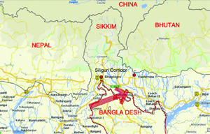
Delhi’s strategic nightmare
Like most of the borders in South Asia, the Siliguri Corridor, also known as the Chicken’s Neck, is a cartographic relic of the British decolonization process. The corridor at its slimmest point is barely 14 miles between the Bangladesh and Nepalese borders. All land trade between Northeast India’s 40 million citizens and the rest of the country traverses the Siliguri Corridor. A single-line railway is all that carries rail-based freight across the Siliguri. The harsh topography of the region makes the railway and roads subject to damage from frequent landslides and natural disaster. India’s Northeast is known for its record levels of rainfall.
Siliguri is on the top of the list of India’s strategic anxieties. Indian strategists have envisioned a future scenario where the Chinese may simply bypass and drop special force to choke vulnerable Siliguri Corridor and cut off the Northeast. China’s diplomacy with Bhutan gives reason to take this possibility seriously. China began in late 90s a concerted diplomatic effort to yield a border claim with Bhutan in exchange for the Doklam Plateau. The territorial swap with Bhutan’s Chumbi valley placed in China’s hands the key to India’s choke point in the Siliguri.
Siliguri’s vulnerability
In acknowledgement of its importance to India’s national security, the state maintains a heavy patrol presence in the Siliguri region. The Indian Army, the Assam Rifles, the Border Security Force, and the West Bengal Police all patrol the region. India’s Research and Analysis Wing (RAW) is known to closely observe Nepalese, Bhutanese, and Bangladeshi activity in the region as well.
The Siliguri Corridor is a terrifyingly vulnerable artery in India’s geography. For Indians in the Northeast, every look at the map is a sobering reminder of just how fragile their physical and economic link to the rest of the country. Unlike so many of the problems India faces, the Siliguri Corridor’s vulnerability is a cruel endowment of political geography and essentially one it is stuck with. It is barely 5 km from the southern edge of the Chumbi valley where the Chinese are active in building communication infrastructures.
Source: Weekly Holiday

’র তথ্যচিত্র")


