Large parts of the rivers Buriganga and Turag are on the brink of being occupied. This is because the Inland Water Transport Authority (BIWTA) has wrongly positioned boundary pillars while demarcating the river boundaries around Dhaka. Four water bodies including extensive wetlands connected to these two rivers are at the risk of being filled because of this.
This information was revealed in a survey report published by the River and Delta Research Center (RDRC), an organisation focused on river and environment. The report published on Saturday said half of the newly installed pillars have been incorrectly placed.
BIWTA has questioned the survey data as well as the authority of the organisation for conducting such a survey. The government-owned BIWTA is spending Tk 8.5 billion (TK 850 crore) in this project which includes river development.
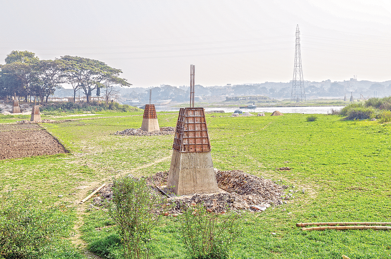
Earlier, following a writ petition filed with the High Court in 2009, the court had passed an order to demarcate the boundaries of the rivers around Dhaka. In 2010, BIWTA set up boundary pillars along Buriganga and Turag rivers.
Syeda Rizwana Hasan, chief executive of BELA, told Prothom Alo that Buriganga and Turag cannot be saved by pillars installed on the basis of wrong demarcation. The boundary of these rivers should be fixed regardless of any influential person and by abiding by court orders and scientific data
That time too environmentalists had protested that the pillars had been wrongly placed. After extensive media coverage, in 2014 a committee headed by a joint secretary of the land ministry reviewed the matter. The committee reported that one-third of the 6,000 pillars were put in wrong places. It was also revealed that some of the river occupants were even able to legitimise their illegal occupation.
In 2018, the government started work on installing pillars again. RDRC conducted the survey on these newly established pillars.
RDRC surveyed the location of 3,006 pillars installed from 2016 to December 2020. It was seen that 1,915 pillars have been placed in wrong positions. The survey was conducted through global positioning system GPS and field surveying. The survey followed the definition of demarcation set by the High Court.
Not only in the rivers, BIWTA has even installed pillars along 12km of the embankment of Buriganga and 4km of Turag. It is feared that Gabtoli, Kaundiya, Biruliya and Ashulia wetlands around the Buriganga and Turag rivers may be filled and grabbed quickly. Most of the wetlands (bils) are private owned.
Earlier, Bangladesh Environmental Lawyers Association (BELA) and the research organisation Centre for Environment and Geographic Information Services conducted a survey about the occupying of water bodies of a portion of Turag. The report states, all the installations nearby including the Tamanna Park have been built on landfills on the rivers.
Syeda Rizwana Hasan, chief executive of BELA, told Prothom Alo that Buriganga and Turag cannot be saved by pillars installed on the basis of wrong demarcation. The boundary of these rivers should be fixed regardless of any influential person and by abiding by court orders and scientific data. Besides, the people who are making these rivers more vulnerable by wrong demarcation repeatedly and wasting government money by installing the pillars in wrong places, should be identified. Such errors will continue to be repeated if no action is taken in keeping with the laws.
A visit to Tamanna Park revealed that two new boundary posts have been installed behind the park. Such posts can be seen in most parts of Turag while going from the side of the park to Uttara through Diyabari area.
Abdur Rahman, a resident of Diyabari, told Prothom Alo that even a few years back, water used to flow by embankments during the rainy season and small boats and cargo trawlers still come here. But this part of Turag is disappearing rapidly as it was being steadily occupied.
The wetlands of this area are extended parts of Turag and Buriganga. According to the Bangladesh Environment Conservation Amendment Act 2010, filling such wetland and building any installations there is banned. But as a result the boundary pillars installed by BIWTA, excluding large parts of the rivers and wetlands, this area will be recognised common lands outside the river. As a result, the legal restrictions to fill them will be relaxed.
Mohammad Ajaz, head of the RDRC’s survey team, told Prothom Alo that the High Court had issued instructions to protect the rivers of the country. The government is also very keen on this. But if the rivers are demarcated one after the other in such a way, these can no longer be protected.
Nurul Alam, director of BIWTA’s project on river development, including the installation of boundary posts, said, “Research institutes do not have the authority to conduct research on rivers. It’s not that easy. The government, led by the land ministry, has set up the boundaries of the rivers with relevant research institutes and people with technical knowledge. It took three or four years to this this work, yet in a matter of days another organisation claims that everything is wrong. It can’t be wrong. We have installed all the pillars in compliance with the government survey. Not a single pillar fell into the river.”
In order to protect the rivers of Dhaka and to install boundary pillars, there are plans to set up 10,720 pillars under this project worth Tk. 8.5 billion (850 crores) taken from BIWTA
General secretary of Bangladesh Paribesh Andolon (BAPA), Sharif Jamil, told Prothom Alo that demarcation of the rivers was the first task according to the directives of the High Court. Instead, the occupation of the rivers is being legitimised by placing these pillars. These pillars need to be removed to determine the actual boundary of the rivers. To do this, all the wrongly placed pillars should be removed.


